Property Record
3926 N Highway 27, Carrollton, GA 30117
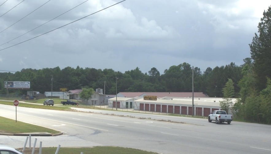
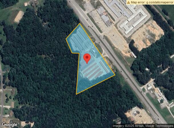
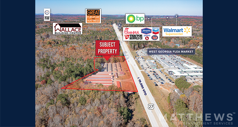
This Property Is For Sale
NEARBY LISTINGS FOR SALE OR LEASE
-
-
View all Carrollton listings for sale on LoopNet.com
Property Detail
3926 N Highway 27
071-0097
MINI WHSES/4.69AC HWY 27 N
Publicstorage
Carroll
X
Georgia
13143C0250B
4.69 AC
2024
W Carroll County
2024
Atlanta
910301
Atlanta-Sandy Springs-Roswell, GA
51,408 SF
DEMOGRAPHICS near 3926 N Highway 27
1 Mile
3 Mile
5 Mile
2024 Total Population
936
4,253
22,336
2029 Population
1,053
4,793
24,987
Pop Growth 2024-2029
+ 12.50%
+ 12.70%
+ 11.87%
Average Age
37
38
37
2024 Total Households
344
1,517
7,942
HH Growth 2024-2029
+ 12.79%
+ 12.79%
+ 11.94%
Median Household Inc
$39,687
$49,493
$55,541
Avg Household Size
2.70
2.80
2.70
2024 Avg HH Vehicles
2.00
2.00
2.00
Median Home Value
$245,945
$231,494
$186,849
Median Year Built
1985
1989
1990
Nearby Places
- Restaurants
- Banks
- Shops
- Fitness
- Groceries
Nearby Properties
Address
Land Use
TOTAL SIZE
Lot Size
Zoning
Address
Land Use
TOTAL SIZE
Lot Size
Zoning
932,068 SF
150.44 AC
I
Address
Land Use
TOTAL SIZE
Lot Size
Zoning
86,316 SF
12.85 AC
C2
Address
Land Use
TOTAL SIZE
Lot Size
Zoning
109,300 SF
127 AC
I
Address
Land Use
TOTAL SIZE
Lot Size
Zoning
22,780 SF
1.36 AC
C2
Address
Land Use
TOTAL SIZE
Lot Size
Zoning
39,500 SF
15.36 AC
OI
Address
Land Use
TOTAL SIZE
Lot Size
Zoning
11,900 SF
2.48 AC
C
Address
Land Use
TOTAL SIZE
Lot Size
Zoning
29,600 SF
11.24 AC
001
Address
Land Use
TOTAL SIZE
Lot Size
Zoning
29,600 SF
3.73 AC
C
Address
Land Use
TOTAL SIZE
Lot Size
Zoning
22,572 SF
2.62 AC
C
Address
Land Use
TOTAL SIZE
Lot Size
Zoning
22,552 SF
3.74 AC
002
Address
Land Use
TOTAL SIZE
Lot Size
Zoning
8,130 SF
1.21 AC
C
Address
Land Use
TOTAL SIZE
Lot Size
Zoning
26,348 SF
5.50 AC
C
Address
Land Use
TOTAL SIZE
Lot Size
Zoning
47,320 SF
18.47 AC
C
Address
Land Use
TOTAL SIZE
Lot Size
Zoning
4,950 SF
1.76 AC
C2
Address
Land Use
TOTAL SIZE
Lot Size
Zoning
9,804 SF
3.84 AC
C
Address
Land Use
TOTAL SIZE
Lot Size
Zoning
4,827 SF
1.60 AC
RESIDENTIA
Address
Land Use
TOTAL SIZE
Lot Size
Zoning
7,072 SF
36.89 AC
COMM
Address
Land Use
TOTAL SIZE
Lot Size
Zoning
4.56 AC
002
Address
Land Use
TOTAL SIZE
Lot Size
Zoning
11,241 SF
2 AC
002
Address
Land Use
TOTAL SIZE
Lot Size
Zoning
20,100 SF
3.27 AC
C2
Address
Land Use
TOTAL SIZE
Lot Size
Zoning
5,530 SF
1 AC
C
Address
Land Use
TOTAL SIZE
Lot Size
Zoning
13,278 SF
1.86 AC
C
Address
Land Use
TOTAL SIZE
Lot Size
Zoning
9,230 SF
19.08 AC
A
Address
Land Use
TOTAL SIZE
Lot Size
Zoning
4,680 SF
1.45 AC
002
Address
Land Use
TOTAL SIZE
Lot Size
Zoning
3,538 SF
1.04 AC
C
Address
Land Use
TOTAL SIZE
Lot Size
Zoning
9,984 SF
1.64 AC
C2
Address
Land Use
TOTAL SIZE
Lot Size
Zoning
3,652 SF
1.17 AC
C2
Address
Land Use
TOTAL SIZE
Lot Size
Zoning
286.25 AC
AG
Address
Land Use
TOTAL SIZE
Lot Size
Zoning
4,036 SF
1.03 AC
C2
The World's #1 Commercial Real Estate Marketplace
Connect with us
© 2025 CoStar Group
The information above has been obtained from sources believed reliable. While we do not doubt its accuracy we have not verified it and make no guarantee, warranty or representation about it. It is your responsibility to independently confirm its accuracy and completeness. Any projections, opinions, assumptions, or estimates used are for example only and do not represent the current or future performance of the property. The value of this transaction to you depends on tax and other factors which should be evaluated by your tax, financial, and legal advisors. You and your advisors should conduct a careful, independent investigation of the property to determine to your satisfaction the suitability of the property for your needs.